GIAJ has produced new tools to promote the use of hazard maps
- Would you like to identify the vulnerability of the area in which you live? -
Sep. 15, 2021
GIAJ set the "Realization of a disaster-resilient society" as a priority issue in the Ninth Mid-Term Business Plan, which started in April 2021, and has been promoting the use of hazard maps.
As part of this initiative, we have produced two types of PDF leaflets intended to promote hazard maps: the "Flood Disaster Edition" and the "Earthquake Disaster Edition". We had the cooperation of the Ministry of Land, Infrastructure, Transport and Tourism (MLIT) in producing the "Flood Disaster Edition".
Through the leaflets, you can access a website that contains the hazard maps of the municipalities you live in, and learn the key points to check.
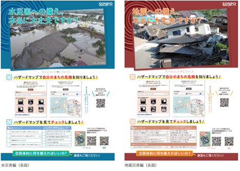
Main points included in the leaflets
Flood Disaster Edition
To protect people from flood disasters, we introduce:
- "My Timeline (Disaster prevention action plan for each resident)";
- a tool for creating “My Timeline” of the MLIT; and
- evacuation information (updated in May 2021).
To protect dwellings from flood disasters, we introduce:
- images of house damage caused by flood disasters;
- general insurance that covers damage such as high winds, floods, and snow; and
- preparations that can be made now to reduce flood disaster damage to homes.
Earthquake Disaster Edition
To protect people from earthquakes, we introduce:
- tips on protecting ourselves from shakes and family members not getting dispersed.
To protect dwellings from flood disasters, we introduce:
- examples of reconstruction costs in the event of an earthquake;
- earthquake insurance; and
- preparations that can be made now to reduce earthquake damage to homes.